Cycling route: Malaga > Puerto de la Torre > Casasola lake > Villanueva de la Concepcion > Almogia > Campanillas > Malaga
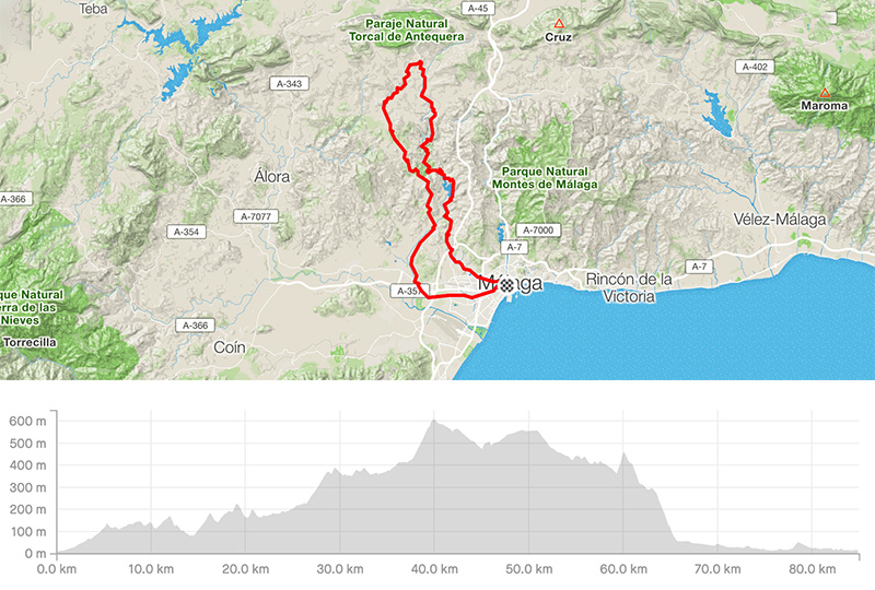
Distance: 85.01km
Elevation gain: 1463m
Elevation max: 609m
Road bike route description
It is a moderate trip around the lake Casasola towards the majestic formation El Torcal and back. From the centre take the streets Marmoles / Martinez Maldonado / Av. de Carlos Haya / Lope de Vega until Puerto de la Torre. Then follow the signs for Almogia, the road A-7075.
This A-7075 will lead you along the lake Casasola to Villanueva de la Concepcion through the long and narrow valley Barranco del Sol. A steady 15km long climb is impressive and finally appears the huge massif of El Torcal. There will be a steep climb to Villanueva. In the village turn left for Almogia through the MA-3403. There you can enjoy the views over the N. P. Montes de Malaga on the left or Sierra del Valle del Abdalajis and even Sierra de las Nieves on the right. After 2km turn left through the MA-3402 to get a cool 8km long downhill back to the lake Casasola. Keep for a few kms on the A-7075 again and behind Las Cruces turn right for Campanillas, the road MA-415, later the A-7058 to Malaga.