Cycling route: Malaga > Casabermeja > Villanueva de la Concepción > La Joya > Valle del Abdalajis > Alora > Malaga
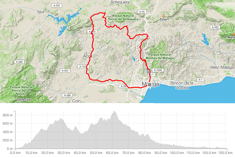
Distance: 131.16km
Elevation gain: 2293m
Elevation max: 893m
Road bike route description
It is a hard route leading to the mountains behind Malaga with really amazing views!!!
From the city center of Malaga take the direction of the Botanic Garden / Casabermeja to the north and cycle along the lake Agujero. You are on the MA-3101 leading to Casabermeja. Some 25kms of a steady climb with the nice views over the N. P. Montes de Malaga on the right. While being close to Casabermeja with a descent to the town and then immediately turn left for Villanueva de la Concepcion, the road MA-3404 and later the A-7075. When coming to Villanueva de la Concepcion, you will meet a steep hill and turn left on the crossroad for Almogia / La Joya on the MA-3404. After cycling along the majestic rock formation El Torcal, take right for La Joya / La Higuera on the MA-4402.
This part is full of short but steep parts. La Joya is a small impressive village at the west bottom of El Torcal. There is the ascent to pass de la Joya between Peak Camorro Alto and Cerro Torrecilla. Going downhill is nice and fast till the main road Antequera – Alora, and there is not much traffic. The descent to Valle del Abdalajis is fast and you can get refreshment there.
There are 2 small hills behind Valle del Abdalajis. The final descent leads you to the valley Hoya de Malaga. The last flat 40kms along Alora / Pizarra and you are back in Malaga through the roads A-343 and A-7054.